How Southwest Florida Luxury Communities Get Planned Around Water
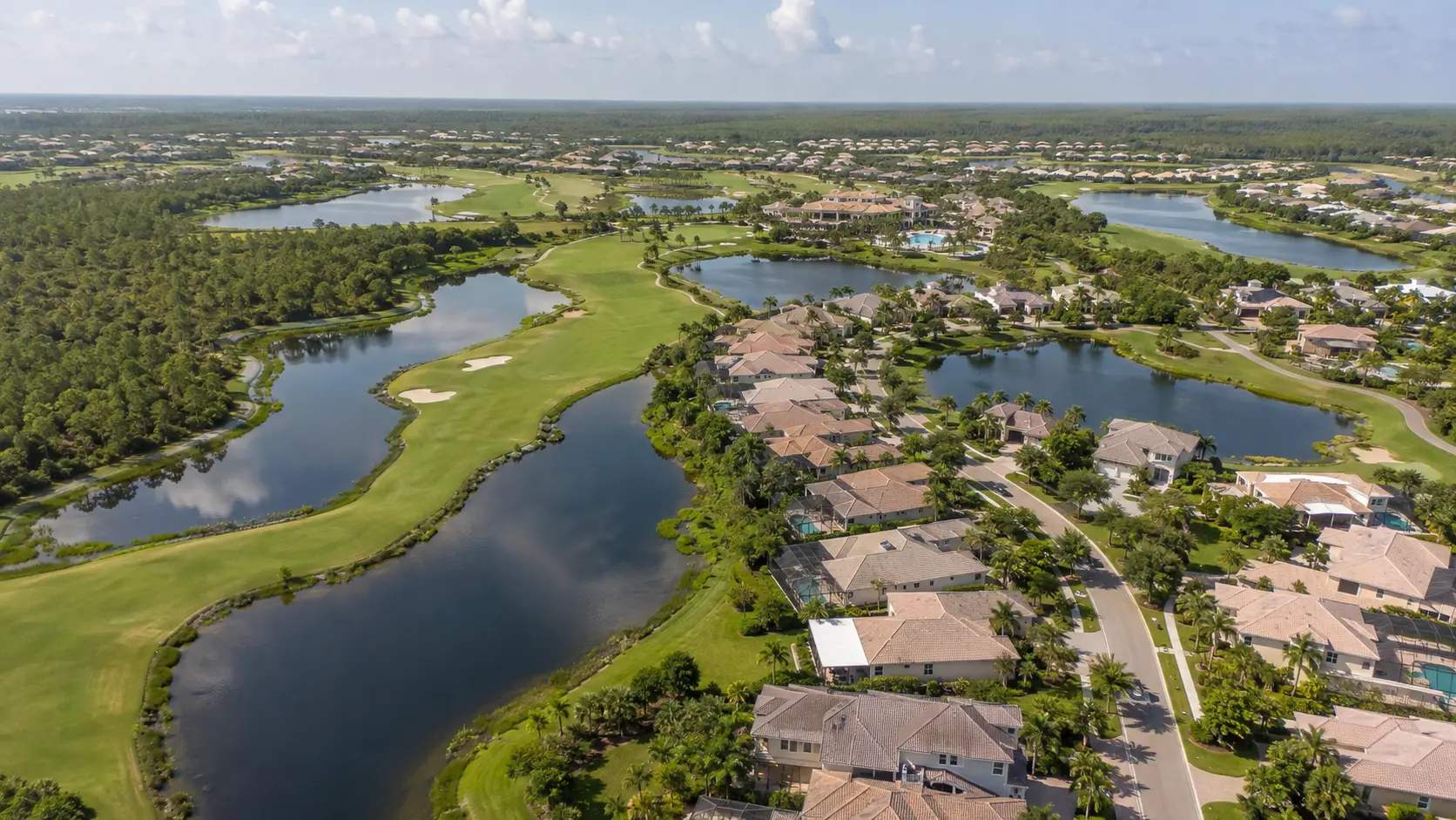
Drive through a gated community in Estero and the layout looks purely aesthetic. Curved streets, long fairway views, lakes at every turn. Almost none of that is decoration.
Master planners in this region start with hydrology, not with lot yield. The water has to go somewhere during a summer storm.
Everything else gets arranged around that answer. It’s why the luxury communities across Southwest Florida share a family resemblance. The engineering constraints are nearly identical from Naples to Fort Myers.
The Site Plan Starts Below Grade
Southwest Florida sits on flat, sandy ground with a high water table. Rainfall here arrives in short, violent bursts.
Planners cut lakes to create fill material and storage capacity at once. Dig a lake, raise the buildable pads with the spoil, and the site solves two problems in one move.
That’s why so many communities feature water at the entrance. It isn’t a design flourish. It’s the borrow pit that lifted the homesites out of the flood plain.
Golf Corridors Double as Drainage Infrastructure
A fairway is a wide, gently graded, permeable strip of open land. It also happens to be the most efficient conveyance channel a planner can build.
Storm runoff moves along the rough and into the lake system. The course absorbs volume that would otherwise back up into streets.
This dual role explains the shape of many courses in Collier and Lee counties. Holes follow drainage basins rather than pure design logic. Golf routing and stormwater routing are the same drawing.
Elevation Rules the Ground Floor
Coastal parcels fall into mapped hazard zones with different construction requirements. The federal coastal flood hazard mapping sets the baseline for how low a finished floor can sit.
In higher hazard areas, living space has to rise above the base flood elevation. Designers respond with raised entries, garages under living space, and open pilings near the water.
That constraint shapes the whole street picture. Front doors sit up a flight of steps. Entry sequences get longer and more ceremonial almost by accident.
Architects here treat elevation as a design driver, not a code hurdle. The best projects make the lift feel intentional.
Orientation Fights the Afternoon Sun
West facing lots sell well because of sunset views over water. They also absorb brutal afternoon heat gain.
Planners counter with deep overhangs, recessed glazing, and lanai depth of ten feet or more. Screen enclosures cut glare while keeping the view open.
Southern exposure remains the quiet favorite among repeat buyers. Pool decks stay usable through more of the day. Second home buyers ask for it constantly.
Density Gets Hidden, Not Reduced
These communities aren’t low density in the way they appear. Planners cluster homes tightly, then wrap the clusters in shared green space.
A villa neighborhood might hit six units per acre. Because it fronts a preserve and a lake, it reads as spacious.
The perceived openness comes from sightlines rather than acreage. Every lot borrows the view from land it doesn’t own.
The Amenity Core Anchors the Plan
Clubhouse siting decides how a community behaves day to day. Planners usually place it near the entry or at the geographic center.
Entry placement keeps club traffic away from residential streets. Central placement makes the club feel like a town square instead.
Newer projects in Estero and Bonita Springs favor a walkable core. Fitness, dining, racquet courts, and a resort pool cluster together. Golf then radiates outward from that hub.
Amenity layout tracks strongly with long term demand. Buyers respond to a short walk.
Three Planning Approaches Compared
| Approach | Water strategy | Typical result |
| Golf first routing | Lakes fitted around finished holes | Strong course, weaker lot views |
| Hydrology first routing | Basins set before street grid | More waterfront lots, better drainage |
| Preserve driven layout | Wetlands kept and buffered | Lower density, higher lot premiums |
| Tower and podium | Structured parking above grade | Vertical density with protected views |
What Design Teams Should Take From This
The lesson travels beyond Florida. Any flat coastal site rewards planners who solve water before they draw streets.
Fairways, lakes, and preserves earn their space by doing infrastructure work. Treat them as amenities alone and the numbers stop making sense.
Elevation, orientation, and sightlines then handle the rest. Get those three right and the architecture has room to be quiet.